Thursday, 24 May 2018


The Journey North. Day 18.  Wednesday 9th May 2018

From: Talladale- Opposite Victoria Falls       To: Beauly   GR:                Mileage: 139

We were awake and off site by 0800hrs. We needed to get into phone range to speak to Tracey.    
I needed my Tax Reference Number to speak to 
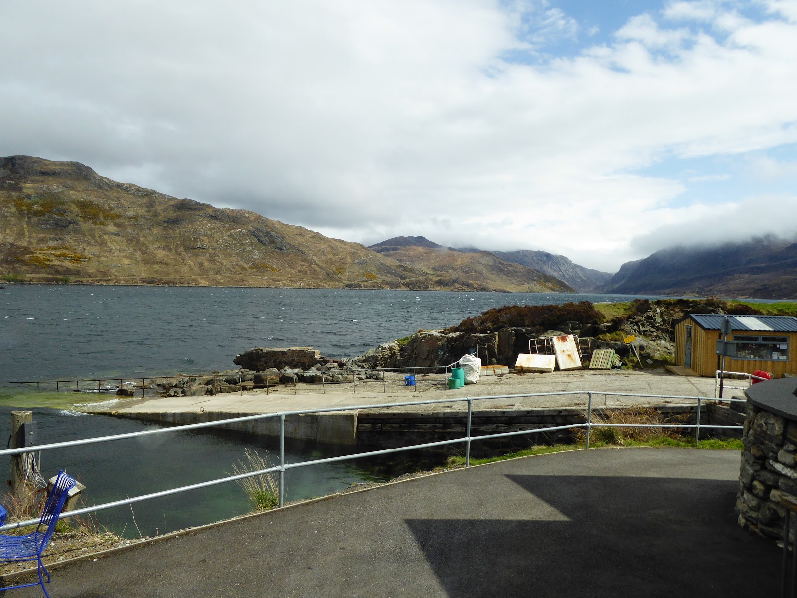
the tax office. We drove South East along Loch Maree until the road junction at Kinlochewe and turned right towards Torridon on the A832. We are now in  Glen Eighe. This is another single track road but stretches the length of the Glen about 8 miles. It is a pleasant, undulating road and has a real desolate feel to it. Quite pleasant really. We pass one potential spot for overnight camping if you were looking and who should be in it but our Dutch friends in the 4x4 Landcruiser. He was looking out as we drove slowly past. I beeped, he waved.

Now at the Torridon junction next to the National Trust for Scotland it was 0900hrs. We waited an hour for Tracey to ring but she was tied up on a business call. We drove on. Passing a look out she rang, we pulled in, during our long telephone conversation numerous others stopped and took pictures including a coach full. Out, snap, get  back in and away. ‘We’ve done Scotland’.

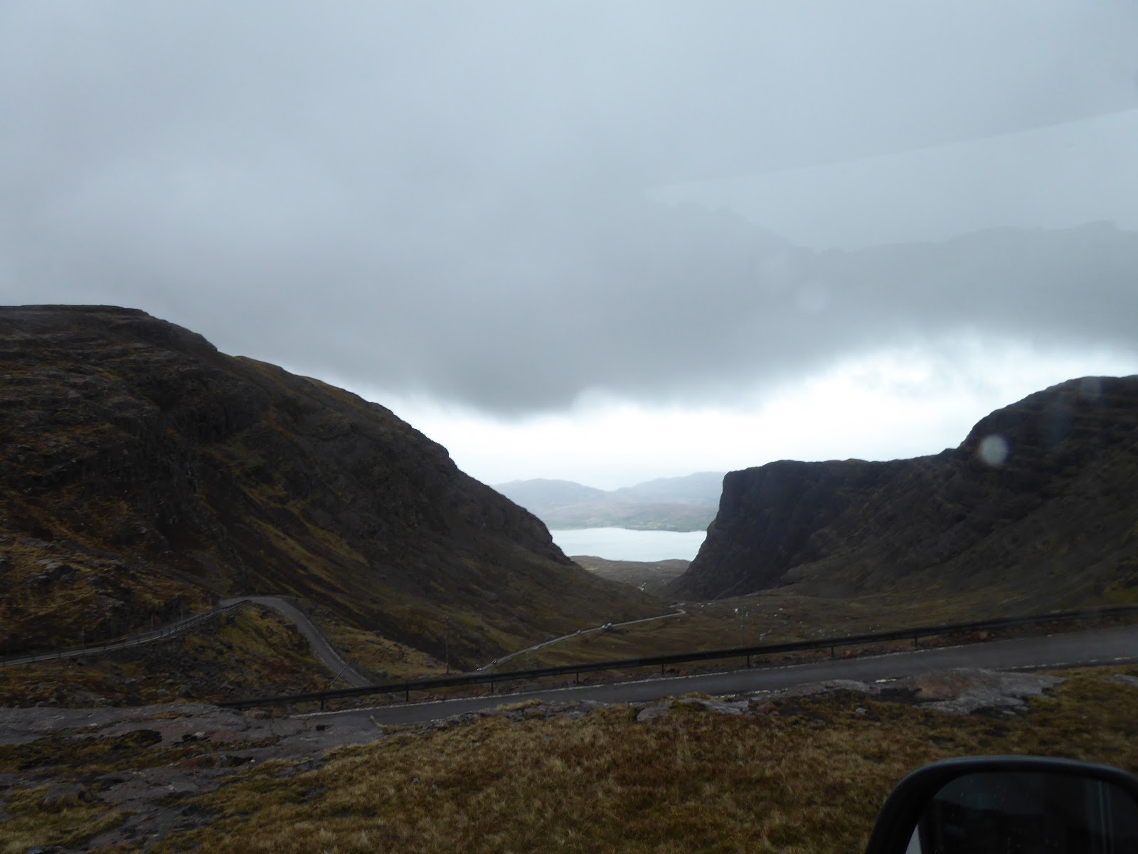
Misreading the signs I turned off the Applecross coast road and headed up a long valley into the hills. This was the A896, marked on the map as single track with passing places. We climbed, all seemed pretty easy, we were soon over the saddle and dropping down the other side. ‘Well if that was Applecross Pass, that was nothing I thought’ What’s all the hype about? Then it occurred to me we had not driven any of the hairpin bends the pass is infamous for. Neither had we seen the caravans and long vehicles forbidden notice. Whilst I mused over this I noticed ahead now the head of another Loch and a road crossing its head and disappearing uphill. That’s it I thought. There was ‘the sign’ We drew alongside the sign, took a snap of it and drove on. I had misgivings. I had wanted to drive the pass. Why? I don’t know. Perhaps to prove we could. Perhaps because many camper folks on Forums and those we had met said ‘No don’t do it.’

I pulled into the lay-by, switched off and pulled out binos and tracked the road disappearing into dark almost black hills and sky. Thinking to myself, I drove on a little further but still the thought of driving to the top niggled at me. I pulled over again. I turned to look at Jackie. Her face told me she knew what I was about to do. I said ”Sorry but I won’t be this way anytime soon.” I did a quick U turn in the road and headed for the pass. So to speak.
We've done the 'low level' route let's try the higher route!
 I stopped at the little bridge at the start of the road near the warning signs to check on two motor bikers. “You guys go on ahead of me I don’t want to hold you up.” “No we’re not going, it’s too windy.” “Wise decision.” I replied and drove on.

The pass starts out OK. We all say that!
Funny how some words come back to haunt you. At that point the wind was OK-ish. I can appreciate why bikes would be cautious but we are 3500kg. The road all single track was OK at first but as is the way of things got gradually narrower till the single track was ‘single track’ the edges worn away to rubble by the winter ice and storms. We now entered an area where the road switch backed it turned back upon itself continually, not hairpins these we could not see and were yet to come. Now you really had to plan your next passing place as there were long gaps between. Check ahead, check the size of the vehicle approaching and either proceed if he’s stopped or you stop if he’s rolling towards you.
Water off the waterfalls being blown uphill.


There were a few workmen on some sections trying to repair crash barriers where they existed. The wind had picked up dramatically now as we were nearing the top. To my amazement a Keuhe and Nagal Brewery lorry was headed towards us a few bends up. What the hell would happen now. We drove on and there by a miracle for us he was pulled into the only passing place suitable for his length. It would have been awkward in a car to pass, for us anywhere else and we would have to reverse a very long way back downhill!! Not an attractive proposition.

Not long after we stopped again, to allow a car pass. “Look at those waterfalls, the water is being blown back uphill.” I said. Now ‘stopped’ the van was rocking quite violently, when there was an almighty ‘bang’ and the whole van filled with a rush of wind and cold air. “What’s that?” asked Jackie. “That was the roof blowing off. Unbuckle and get back to check.” I couldn’t stay where we were and drove ever upwards. Damage Control reported “The roof’s gone.” We scanned away down into the valley we could see no sign of the roof section. This measures about 3 ft x 2ft in old money. We could do nothing for the moment but switch on the heater full blast and continue up towards the pass. We hadn’t even made the difficult hairpins yet!

The road back down.
 
One of the hairpins.
 
It's all dark and gloomy.
By now not much was being said.


It was my intention on reaching the top, where there is a small parking area, to have a brew and some lunch. Now with it raining slightly and a hole in the roof big enough to mount a Fifty calibre I merely turned the truck around and started back down the way we had come. “What are you doing?” Jackie asked incredulously. “Me, I’m driving back down, I need you to plot me a course to the nearest lumber yard, we need to seal the hole in the roof before it really starts to rain.”


“At least we needn’t worry about the drip we thought we had on the window I reckon.” said Jackie. I think that broke the ice. We decided our best option was to ring Tracey and get her on the internet at home to look for timber yards. Eventually after much thinking I came to the conclusion that our best bet was to run for Inverness. There was a B+Q there. Seventy miles away. They would have sheet timber, battens and heavy duty screw eyes to hold everything down and seal the gap. I already had on board Lidl’s finest folding saw and para cord.


At B+Q we selected various timber and hardware, a gimlet and retired to the truck to affect repairs. Ably assisted by Carpenters Mate First Class Jackie we soon had the Jury rigged hatch in place within a very short period of time. “I thought you were a bit quiet on the journey across to Inverness. You were mentally building the hatch weren’t you?” “Sweet heart, I’m not just a pretty face and a brilliant driver.” I replied. “No you’re not are you.” Jackie’s reply was a bit too sharp and I felt a little cutting!

We drove next door to Miso’s a camping outdoors facility, a huge outdoors shop for a coffee but ended up buying new walking boots for Mike.

Onto Beauly Caravan Park for the night. £24 for the night! I think we were both feeling a bit chin strapped.

The Journey North. Day 17.  Tuesday 8th May 2018
From: Grunaird Bay      To: Talladale- Opposite Victoria Falls   GR: NG888721   Mileage: 30
Yesterday we mentioned Gruinard Island. In 1942 this mile long by half mile wide island was the subject of anthrax testing on sheep and the land. It was thought that we might well use Bio warfare against German or Japanese cities.  It was not until April 1990 that it was declared safe. 
Gruinard Island
 In 1987 £0.5 million was spent on decontaminating the island with 280 tonnes of formaldehyde and to remove topsoil.
NATO Re-fuel depot on Loch Ewe. A sea Loch.
Talking about refuelling...!


Loch Ewe 6th century chapel. inWW2 Loch Ewe was the rv point for Russian convoys Scapa Flow was to dangerous open to axis air attacks. The first 19 departed in 6th feb 1942 and the last 30th dec 1944 of 489 merchant ships sailed from here only 16 were sunk along with 5 escort vessels.

The NATO Refuelling base is still operational near Aultbea.

Spent from 1500hrs at the forest site overlooking Loch Maree. Wild camping and some nice walks around the LOch. Fantastic views. Got chatting with a nice young Dutch family. Nice evening.


Where is everyone?


The Journey North. Day 16.     Monday 7th May 2018

From: Balnakeil Bay Durness       To: Grunaird Bay       GR: NG953899         Mileage: 109

Slight rain on reveille but it soon cleared, a bit grey today. The compass needle has swung. Today we turn South. There are different views and aspects today as we head towards

Ardvreck castle. It’s a ruin really. It  stands on the South of Loch Assynt. Its more of a tower house. We stop look and decide we will give it a miss.

Lots of views of sea lochs and those low islands in the bay. Sandy beaches are more prominent but not as many as I thought. You probably need to drive off the main A road to find em.
The Kylesku Bridge
 
View from the Kylesku Hotel onto Loch
 
Langoustines.
 
 
Loch Glencoul at Kylesku


I had planned lunch at The Kylesku Hotel on Loch Glendubh joined to Lochs and ??? This is where in WW2 the Royal Navy trained its X-Craft and midget sub warfare crews. Also from here they sailed for the Norwegan Fjords and to sink the Tirpitz. That task eventually being accomplished by RAF 9 and 617 (Dambusters) Squadrons.

Lunch was £85.  We had the best table in the house. I had langoustines and Jackie grilled fish with lentil and cous cous salad. I ordered a cheese board she said is that for three “No, just me.” “No I mean do you want three cheeses.” Strewth that was £14. Whilst I prevaricated she said “I’ll get you two, cheddar and brie.” “Do you not have any local cheeses?” “No, sorry.” Considering they made such play of everything that was served on the menu was caught shot trapped or?? From the area I wondered about the cheeses. Pretty poor.

Jackie had consumed two locally brewed G+Ts I had a soft drink. My starter Haggis balls.  £85

Drive on in to Ullapool 1788 designed by Thomas Telfod for the British Fisheries Society as infrastructure for the Herring industry. Which my notes tell me was a large ‘town’. I think not. OK its My Bank Holiday but still apart from the local petrols station which had at least 4 pumps a major player then and a queue onto the rd a 12 motorbikes filling and cars waiting on a blind bend I didn’t feel inclined to refuel there.


Turning off the A835 at Braemore we took the A832 on the South shore of Loch Maree and once again started to climb on the coast road to Gairloch. WE had covered about 100 odd miles today. No distance not even Plymouth to Exeter but perhaps up here the amount of consentration needed on these roads especially the single track makes for tiring driving. In fact there hadn’t been that much single track today. The roads were getting noticeable wider and better conditions.

We dropped down off the headland and there before us was a sandy beach bay with a large parking area set back off the road. “That’s the very fellows for me.” In we swung and dropped anchot. Whilst I chatted to our new elderly couple neighbours Jackie had switched on the gas and had a brew going. By the time I arrived inside my T had gone cold. What a lovely couple. Scottish but a delight. Must have been in their 70s.
Wild camp in a small car park opposite.


Beautiful evening we walked along the beach. By the time we got onto the beach only across the road I thought about the bubbly we had brought for John O Groats and hadn’t used and thought about doubling back for it but decided no. Too much trouble.

Returning to the truck we ate a rather light meal of salad and cheese washed down in my case by a can of Thatchers Haze.

2130 hrs. We hit the sack I was aware of Jackie reading then that was it.

Wednesday, 23 May 2018


The Journey North. Day 15. Sunday 6th May 2018

From: Dunnets Head Lighthouse       To: Balnakeil Bay Durness    GR:NC 392686   Mileage: 93

Slight drizzle as we set off at 1000hrs.
Todays drive of 93 miles is mainly on single track carriageways with passing places.
Fairly typical single track road.
This is quite easy to drive. Everyone is attuned to other vehicles and motorbikes. Drive slower and with more consideration. We are soon in Thurso. On the A386. There opposite is a Tesco. It’s open. On a Sunday? Gone are the days when all of Scotland closed on the Sabbath.  In we pop for some rations. We seem to buy more than we eat.
 In need of replacement glasses for Mike a shop assistant sends us down beside the river. “Look out for the pirate.” Pirate my arse. We couldn’t see hide nor hair of him or anything that looked like a shop selling glasses. We continued.
We are driving West from Dunnet Head to Durness in effect along the flat looking bit at the top of Scotland. It’s not that flat, hilly moorland. Pretty bleak neither ruined croft or habitation just mile after mile of windy roads with thousands of acres of heather yet to bloom.
Mrs Weaver's Café and Gift Shop

We stop at Weavers Gift Shop and café. Mrs Weaver is so quiet and the room is like a church and just as quiet. It's quite intimidating for me!  I had chicken and haggis pie Jackie sweet potato and celeriac with brown bread soup it was delicious and as much as either could eat.

Ceannabeinne Beach near Durness.
"Is that all your life's worth? Twelve pounds!"

We pull in to take a photo of the beach and there is the Golden Eagle Zip Wire.
£12 it’s a steal. Mike’s up for that. That’s equivalent to £3 a second on the wire!.

Smoo Cave.
 "Too late sonny were closed."
" I've driven 700 miles to see this."
"Should have driven a bit faster."
Smoo Cave.

Coccoa Mountain. In the home of the old cold wars RAF station. We drove down the road to the beach and found a spot to hull down for the night.

We walked along the long crescent  shaped beach and away into the dunes. It was sunny but windy.
 

We are parked away in the distance on the edge of the beach.


Another 'Wild Camp' spot.


 Jackie keep moaning when other campers arrived taking up 'her' view.
Camped overnight  it got even windier.


Another deserted property.
 
The mist on the Ben.
 
Loch Eriboll. Scene of the surrender of 30 German U Boots in May 1945.


The Journey North. Day 13.       Friday 4th May 2018
From: Helmsdale       To: John O Groats       GR: ND381734     Mileage: 62
The WW1 Memorial Clock
Jackie had spent a somewhat restless night. The automated chime sequence of the clock in the Seaforth Highlanders War Memorial struck every quarter hour through the night. Accompanied by hourly chimes! It seems the locals get off to work early hereabouts. The timber lorries started driving past our car park about 0600hrs. By 0730hrs I was up and dressed. First time either of us was up before 0800hrs. There was a public loo on this car park. Space for 6 cars, three disabled bays and an electric charge point. I’m not sure we even have those in Plymouth!

I walked onto Thomas Telford’s bridge, the original crossing of the river and looked downriver towards the sea at the new bridge constructed in the 1970’s. They knocked down an ancient Norse castle to build that! The river below is famous for salmon runs and breeding. On the end off the bridge was a Spar shop. Not expecting for one moment to find any Croissants being sold in I walked with perhaps an air of hopefulness if not expectancy. There were no croissants but I immediately spotted some bread rolls and could smell bacon. Things were looking up. The young woman behind the counter was outgoing and friendly with a lovely smile. We chatted. She opens at 0600hrs and closes at 2200hrs. Her customers, not forest workers as I had suggested, but rail workers and tradesmen. It was quite large, bright and clean and the only shop around for miles and miles. I bought two bacon baps and hurried back to the wagon. Jackie was up and the kettle was on.
We sat on the wall outside overlooking the river and munched on our bacon baps.
The Emmigrants Statue.
The clearances still after hundreds of years touch raw nerves!
A quick walk up to the War Memorial. As much in an attempt to silence the clock as anything. Around to the ice house, the emigrants statue and memorial and then down to the harbour. We might have been better off parking here. Back to the truck and off.
The New Helmsdale Bridge.
Jackie was the duty driver and I the navigator. Up here you breathe-in involuntary as you pass a cyclist! It’s narrow in places. As I was Nav it is down to me that I missed one of the few places I was really intent on visiting. The Whaligoe Steps. These are three hundred odd steps down the cliff face to a small fishing ledge. Harbour would be too grand a term for it. We learnt later that the local council do not signpost it as there are no handrails and can be dangerous when wet!  Therefore what we don’t see we cannot visit! By the time we found somewhere large enough to turn….Bollocks forget it.

Before we knew it we were in Wick and looking for the heritage museum. We eventually found it and parked outside. It was a tiny cottage and they wanted £4 a head. We agreed no and went walkabout. Across the river we spotted a Weatherspoons. Ah Wi-Fi. We entered. Might as well have a bite. A single bacon bap does na keep a man alive. Two x scrambled eggs and coffee. £6-95.
Six old ladies were sat opposite gabbling on in a broad Scottish accent. They had seemingly brought their own chocolates and cakes to eat. What the staff thought of that I am uncertain but they ignored it. I had spotted two solitary  Ferro Rocher chocs. All that remained from a tray of twelve. I walked over and before long returned with the chocs leaving the girls giggling away. Jackie looked up and said “Forgive my husband, he’s terrible”. “We know.” They chorused back.
J.S.Lowry's 'Black Steps'
We cannot find the Tourist info centre but found the shortest street in the UK. No 1 Ebenezer Place Wick. It is officially the shortest street in the world according to the Guinness Book of Records at 2.06 meters. It houses a restaurant now and is supposedly a fine dining experience. Walking back towards the harbour and docks we saw where the first bombs fell on UK soil in July 1940 killing 15, 8 of which where children. Further along by the harbour we saw J S Lowry’s Black Steps. Check it out on the internet. A quick walk around the harbour. Drop a few coins in the lifeboat collection box and back to the truck.
1340 Arrive Noss Head and the lighthouse for Castle Sinclair and Girnigoe ruins. This magical place dates from the early 13C. Is perched on top of the cliffs literally overhanging the sea some 30 meters below. In previous years it also housed the Lord Protectors Parliamentarian troops during the English civil war. It fell to its ruinous state in the 1700’s. This will be without doubt the best place I will visit on this our month long trip to Scotland. I am certain. It is easy to imagine a Viking Longship putting into the sheltered cleft between the rocks. If you don't see that you have neither imagination or soul.


It is all too easy to imagine a Viking Longship putting in here!

Where we were parked at Noss Head close to the lighthouse is where during WW2 there was a large radar station. Most traces of which now gone apart from a few stone buildings used by the local farmer as cattle sheds.
John o Groats next stop.
The campsite although not full, all the Leckie points were taken by The Autotrail Club on a round Scotland rally.  Twenty of ‘em. The organizers came from….wait for it…. Cornwall. Bude to be exact. It was £18 for the night. We had a quick brew and then walked across the road to visit that famous sign  and have our photos taken.

A walk around the harbour.

A few more photos and back for some of Nanna’s Magic soup as Callum calls it. Brought from home frozen.
A beautiful evening. Perhaps the best yet, There haven’t been that many to chose from.

The Journey North.  Day 12.   Thursday 3rd May 2018

From: Culloden, Morah Firth       To: Helmsdale   GR: ND026155     Mileage: 74
The morning sun was encouraging but was not to last. Away in the distance we could see the bridge that joined South and North Kessock, spanning the relatively small channel that separates the Moray Firth and the Beauly Firth. That bridge, took the A9 further North towards Wick and John o Groats. Our intended route. We were soon to cross it but first we needed rations and fuel. We had spotted on the route into Culloden yesterday afternoon a Tesco Metro and here is where we would shop. Feeling slightly guilty as I felt as a tourist on a route designed to bring more trade and sales into the highlands I ought to be spending in a local shop. The trouble is cost. Yes I know the argument you are about to put forward but on fuel for instance there is a 10p per litre difference. Similarly with the mark up on foods.

Another eighty pounds of diesel was put in the tank. Rations, including four cans of Thatcher’s Haze and some Fevertree mixers for Jackie’s gin amongst the more mundane items such as bread, milk and cheese was loaded and we were off. 

 Here the countryside is fairly flat pastureland a happy change from the high mountains we have been travelling in these last few days. The A9 after crossing the Black Isle then drops down to cross the Cromarty Firth bridge. Looking East we can see seven or so ‘oil rigs’ they might be gas. They might even be redundant awaiting dismantling as this is besides the Beatrice Oil Field. We drove on headed for Dunrobin Castle. Jackie has need of a cream tea here. Passing Tain we note on our left the Glenmorangie Distillery. This was established in 1843 by William Mathieson. Today the distillery has eight tall stills as opposed to the more usual round pot stills. Tours here as in most distilleries are available. 

Following the signs for Dunrobin Castle we turn into a long drive, edged with numerous daffodils. This late in the year they are still looking good. Must be the colder weather up here. Back home, down South they have been finished for a month or more. We park up and pay our £9-50 senior citizens rate to John at the door. He is an elderly gentleman. Resplendent in a tartan kilt, probably that of the Clan Sutherland, complete with dirk in his stocking. Or is it his sock?


The house, it’s oldest part of which is a C14 keep has been added to over the years and enlarged. It was used as a naval hospital in 1915 when a fire was started in the old music room and much of this part was refurbished with major alterations in 1919. 


On arrival we were told that the Falconry display was about to start on the hour at 1400hrs. We made our way out of the castle to the grounds below in the walled gardens and took a seat on the long wooden benches. I have seen a few of these Birds of Prey displays over the years but Andy the presenter was absolutely first class. A wealth of knowledge and a ken sense of humour together with great presentation skills earned him my thanks on completion and an opportunity to shake my hand. He had more of a North country accent, not strong and lived on the estate, breeding falcons and Harris Hawks two birds of which he flew for us today. He had been doing this since he was eleven and he was now forty-seven. I asked did he have a promotional DVD but he said no but wished he had a pound for everyone that had asked that question. “Well then there’s a market for it surely!” “Aye but ma birds take up all ma time.” What a splendid chap. I told him I had driven 700 miles to see his display and would gladly drive that distance again next week to see him again. Indeed I would.

 A cold wind had started to blow in off the Northern North Sea, with the completion it was time for Jackie’s much awaited cream tea. We entered the tea room on the ground floor of the castle. The request for two cream teas raised many questions. The first of which was “What’s a cream tea?” “It’s what you advertise in your brochure.” “Oh really. What is it then?” we explained “Scones, jam and cream. Sometimes with a tiny triangle of salmon or cucumber sandwiches all served with a pot of tea.” “Och, we have all of that. But, na tagether.” the young girl replied, face as straight as a die. I turned away to hide a smile and was caught by an equally young waitress looking at me. I couldn’t resist it. I said “It’s like being in a foreign country.” In as gentle a way as I could. “Aye, we get a lot of you foreigners up here!” By the time I turned back to the counter Jackie had persuaded the first waitress who was serving us to place all the aforementioned articles on a tray and we would buy that. “We could always call it a cream tea I suppose.” I said to no one in particular as the young lady promptly filled to ramakins with whipped cream from a piping bag. Jackie seeing the look of horror on my face turned and speaking quite sharply said “Don’t even mention Rodda’s.”


  We took our ‘cream tea’ into the Fire Engine room and sat by the log fire munching away contentedly. Nice scones, pity about the cream.

 The self-guided tour around the castle completed we made our way back to the truck to continue towards Helmsdale. This small village, isolated for centuries was once a salmon fishing and curing station. In 1814 a brand new village was constructed by the Duke Sutherland to help house those who had been displaced by the Highland Clearances. The very fact it was he who instigated the clearances in this part of the coast is still held against him even today. I made a mistake saying that at least he was a Scottish Laird and no English . I was told in no uncertain manner I was wrong he was English but married the Countess and thus became Laird.

It was into this village beside the river and with its small but still active fisher boats that Mike and Jackie drove.


We pulled onto the car park beside the river Helmsdale and decided here was where we would spend the night.